What it was like to fly into Hurricane Melissa’s eye
Hurricane Melissa
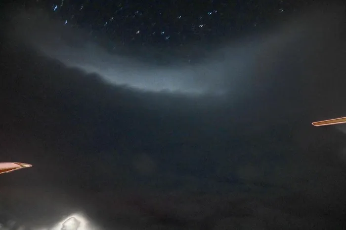
The eye of Hurricane Melissa on Sunday night.
Image: Matthew Cappucci/MyRadar
ON Sunday night, I flew through Hurricane Melissa’s eye - one of the most striking moments of my career and a once-in-a-lifetime glimpse into meteorology that most will never have. It was humbling, mesmerizing and, surprisingly, poignant - equal parts scientifically stunning and horrifying from a humanitarian standpoint.
Days earlier, I debated how to cover the storm. Computer model simulations showed the system had the makings of a monster - one that would later be on track for a devastating blow to Jamaica, expected to bring up to 40 inches of rain, 9 to 13 feet of storm surge and destructive winds to the island nation. One option I had to document the storm: flying through the storm with a Hurricane Hunter.
There are two sets of hurricane hunters - those from the National Oceanic and Atmospheric Administration (NOAA), and a team with the Air Force. I had flown with NOAA’s Hurricane Hunters once before, leaving out of St. Croix in the Virgin Islands in September 2023 to intercept Hurricane Lee. Except Lee, then a borderline Category 3, was weakening. Melissa was strengthening - and fast.
On Saturday night, it put on a pageant of power, metastasizing from a tropical storm to a Category 4 in just over 15 hours. It held steady for much of Sunday before another bout of intensification ensued late in the day. Melissa was about to prove what it was capable of.
For the flight, I was aboard NOAA N42RF, more colloquially known as “Kermit.” It’s one of two specially outfitted P3 Orion aircraft the agency has owned since the 1970s. Kermit would be alternating with its counterpart - Miss Piggy. (A small, plush frog hangs on a windscreen in the cockpit.)
We took off from Lakeland Linder International Airport shortly before 5 p.m.; by 5:30 p.m., we were south of Miami.
- - -
The scene aboard a Hurricane Hunter - and the storm around me
There were 19 people on board the aircraft - mostly pilots, flight engineers and researchers. One was tasked with operating the TDR - tail Doppler radar, a special weather radar built in an elongated cone protruding from the back of the plane. Another crew member handled dropsondes - small instrument canisters dropped from a hole in the floor of the plane. Like a reverse weather balloon, dropsondes collect temperature, pressure and wind data - except on the way down rather than up. Twenty-six dropsondes were prepared.
I knew I wouldn’t have WiFi on the flight. After all, this wasn’t like a typical Delta shuttle. Before takeoff, I had taken one last peek at satellite imagery and reconnaissance data from the previous flight. Melissa’s air pressure was dropping once again - a sign that it was lifting more air from the center and intensifying. An Air Force plane had found stronger winds. And Melissa looked like a symmetric buzz saw on satellite with an eight-mile-wide eye.
Skies near Cuba were blue, interspersed with towering cumulus clouds. Those isolated showers were the first sign of Melissa’s presence. By the time we were near Jamaica, there were two distinct layers in the sky. High, wispy clouds were making for a stunning sunset, catching the dying amber rays as the sun slipped below the horizon. Closer to the sea surface, a few puffy clouds were visible.
The windows transformed into an indiscernible gray as we approached the storm. Even though Melissa was mighty, it seemed relatively small. That’s the secret to hurricanes - compared with midlatitude, nontropical storm systems, they’re tiny. But they pack all their power into that small area, leading to extremely potent winds and waves.
Melissa looked like a telltale Category 5 on satellite, but technically it was harboring Category 4 winds. It was still intensifying, however. By the time we entered the eye, I figured it might reach Category 5 strength.
As we entered the storm, darkness fell. The sun had set, but the darkness looked, somehow, thicker. I could barely see the wing of the aircraft through the dullness. The outside wasn’t a dark abyss, but rather a dismal murk.
There were no visual reference points, lights or landmarks. All I heard was the nearly deafening groan of the propellers humming more intently as we blasted closer to the core. With every second, the turbulence grew - it was the only clue that we were moving. A gentle jostling turned into more dramatic bumps and drops. It was like off-roading in midair, with potholes big enough to swallow an SUV.
“RMW coming soon,” a voice on the headset said. Radius of maximum winds. That meant we were closing in on the eyewall, or the innermost ring of furious winds screaming around the eye. Like an atmospheric sink drain, we were near the middle of the vortex.
Like in any vortex, fluid (in this case air) is spiraling inward. Warm, moist air rushes toward the middle, sapping heat energy from the ocean below. As thunderstorms release heat, that warming lifts the surrounding air. So much air rises that it creates a void of missing air near the surface. Melissa had an 8 percent deficit - it had lifted 8 percent of the air out of its core - that void of sorts is what drives a hurricane’s ferocious inward winds.
As the air curves inward and upward, it forms a ring of thunderstorms 50,000-feet high. Winds in the eyewall reach ridiculous speeds; over the open ocean, winds were gusting 140 mph or more. Eventually, all the rising air in an eyewall collides with the ceiling of the lower atmosphere; we call that the tropopause. Some of the air bounces against that ceiling, curling downward. It sinks (subsides), warms up and dries out. That punches out an oasis of calm: The eye.
Turbulence in the eyewall flung one of my cameras onto the floor. I had my backpack safety-belted into a seat in the galley, a diner booth-like workstation at the aft of the plane. Because we were traveling nearly 280 mph, the 10 mile-wide eye would last only two minutes or so as we completed a penetration. I readied my DSLR camera.
And then it happened. We emerged from the mist. A fingernail moon hung overhead in the deep twilight. I pressed my face against the glass. My jaw dropped.
I was sitting in the middle of a 10-mile-wide stadium of the gods. On all sides, hulking thunderstorms towered high above me - yet, directly overhead, the stars twinkled. With the faint glow offered by the moon, I could see brushstroke-like striations as the clouds in the eyewall swung around the eye at breakneck speeds. But, for a moment, I was in an oasis of calm.
And yet, the winds abruptly dropped to nothing at flight level. The drop-off only lasted a few seconds before the light flow in the eye changed direction. I imagined what it would be like in a boat below - 100-foot waves, sea spray so thick it would be indiscernible from the torrential rain, tornado-like vortexes capriciously slicing through the seascape - not to mention winds of at least 140 mph.
“Center fix,” the voice in the headset said, bringing me back to reality.
I noticed I was beginning to sweat. Then it hit me: I was in an atmospheric chimney. Hurricanes are warm-core systems, marked by a pillar of warmth at their cores. And the temperature inside the eye, even at flight level, was 16 degrees warmer than outside. Even at close to 10,000 feet altitude, it was still swelteringly warm and humid. Some of that warmth was making it into the non-pressurized cabin.
There was something emotional about being in the eye; perhaps it was the poetic sinisterness of knowing what the surrounding eyewall contained, and yet - even fleetingly - being immune to it.
Or maybe it was spending decades marveling over photos of the “stadium effect” that I was now witnessing in person; I suddenly had photos of my own. I was living meteorological folklore.
Above all, it was the cognitive dissonance of knowing what was coming.
Melissa was strengthening into a Category 5 hurricane that would inevitably bring catastrophe for many. As a scientist, I can appreciate meteorological perfection - after all, that’s the only way to get a storm of Melissa’s caliber. But, as a human, I know that millions of people could awaken Wednesday to devastation - shattered communities, an unrecognizable landscape and scarring that will take decades to mend.
Matthew Cappucci is a regular contributor to The Post and a meteorologist for the weather app MyRadar, which funded his travel.