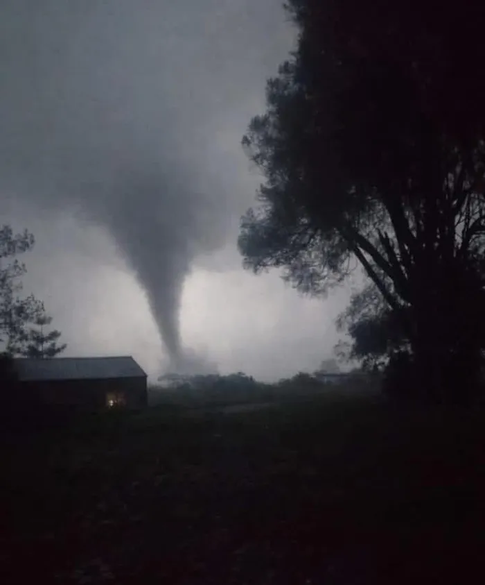
A tornado which occurred for a brief period in Bishopstowe, Pietermaritzburg, according to the SA Weather Service.
Image: Facebook/ Edith Elliott DA councillor ward 37, Msunduzi
Matthew Cappucci
A supercell thunderstorm can tower 10 or more miles high. It can spit out pinpoint lightning strikes, drop grapefruit-size hail, rage for hours and traverse hundreds of miles.
But the secret to a supercell’s power is that it’s a rotating thunderstorm. The entire storm spins. That’s why supercells can, and frequently do, produce tornadoes.
A mature supercell is a pageant of power. It’s atmospheric elegance at its most picturesque, destructive, organised and ominous. I’ve chased hundreds. At times, they take on a life of their own, and you can’t help but feel as if they’re sentient.
But ultimately, supercell thunderstorms are merely the result of perfect combinations of air, water and heat. Below are three different species of supercells. Let’s discuss
All thunderstorms boil down to a basic structure. The “updraft” is where warm, moist air rises. That buoyant air ascends in a turbulent plume, creating those billowing cauliflower-like clouds you often see on humid summer days. The updraft powers the thunderstorms; it’s responsible for ingesting fuel.
The “downdraft” is that crash of cool, dense air that drops out of a storm. Rain and hail chill the air, making it more dense and causing it to sink.
Most thunderstorms are “pulse-type” storms. They begin as an updraft, which then gets chocked by the downdraft as rain and hail fall down into the updraft. That spells the storm’s demise in as little as an hour.
Supercells are different.
They exist in an environment characterised by robust wind shear, or changing winds with height. When a thunderstorm grows tall enough to be affected by those changing winds, it rotates. And strong winds aloft blow the top of the storm downwind, causing the storm to tilt.
So now we have a spinning storm that’s also leaning. Warm, moist air swirls into the spiral updraft. But by the time that air is cooled by rain and hail, it’s blown downwind - meaning the downdraft is displaced 5 miles or so ahead of the updraft. That means the downdraft doesn’t interfere with the updraft, and the storm can charge on for hours.
A classic supercell has a clearly delineated, visible separation between the updraft and the downdraft.
The updraft is visible as a rain-free cloud base, often rotating with appendages beneath. It’s from here that the tornado is born.
To the east or northeast is the downdraft, a shroud of heavy precipitation punctuated by the occasional flickers of lightning. Some of the hail can reach baseball size or larger. Destructive straight-line winds also accompany the downdraft, sometimes upward of 113 kph.
Storm chasers like classic supercells because the rain-free updraft allows the tornado to be visible.
In dry environments, some of the rain falling from a supercell can evaporate before it reaches the ground. That allows the storm’s structure to become even more visible, since there’s no precipitation to obscure the barber-pole updraft.
I’ve chased LP - or low precipitation - supercells without turning on my windshield wipers. Despite minimal rain, these LP supercells are very good at producing large, and sometimes giant, hail. That’s because the drier environment makes storms with fewer raindrops.
Instead, smaller, supercooled water droplets drift around in the cloud. They’re not big and heavy enough to fall as rain, but they can latch onto a growing hailstone and make it bigger.
These HP, or high precipitation, supercells are a pain for storm chasers.
In saturated environments, curtains of rain are swirled around the rotating updraft. That hides the circulation, and any tornado, from view. Chasers who venture up close have to contend with a hidden monster.
HP supercells can produce rainfall rates approaching the ridiculous - sometimes 4 to 6 inches per hour. Slow-moving HP supercells bring severe flooding.
These supercells rarely produce hail bigger than golf balls. That’s because most of the moisture in the storm falls as rain. Plus the plentiful raindrops falling through the updraft slow it down, reducing the upward force that can suspend a hailstone as it grows.